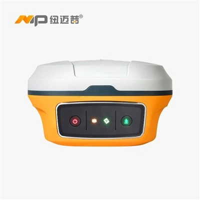
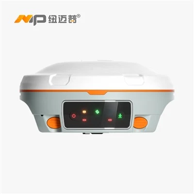
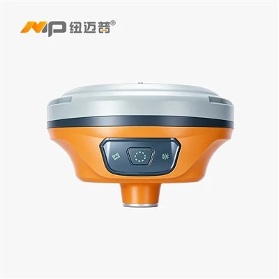
Product Introduction
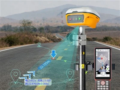
The N9 Laser Dual-Camera RTK is a flagship GNSS receiver that integrates cutting-edge GNSS, IMU, laser, and visual technologies. Its new laser visualization technology displays laser point positions and real-time imagery in real time, while the Laser 3.0 module offers a maximum measurement range of up to 50 meters. Thanks to the integration of laser and imaging technologies, it successfully achieves visual laser measurement and dual-camera staking. With comprehensive upgrades to the laser module and RTK engine, it can measure farther and see more clearly. A completely revamped RTK core and fourth-generation super-inertial navigation system deliver stronger signals and simplify operations.
50m Ultra-Long-Range Laser Measurement
Featuring the upgraded Laser 3.0 module, with a measurement range of up to 50 meters. Where the laser points, it conquers challenging environments and dominates the measurement field.
Laser Visual Measurement at Your Fingertips
With the seamless integration of laser vision technology, the software displays a real-time view of the laser-marked points, overcoming the limitations of the naked eye and making the points clearly visible.
Precise Free-Zoom Targeting
With a clear field of view and free-zoom image display, you can zoom in and out as needed for more accurate long-distance measurements and double your measurement efficiency.
Say Goodbye to Compasses-Stay on Track
Dynamic route guidance, laser point layout support, automatic switching between dual-camera near and far modes, and an immersive layout experience-get it right the first time.
Product Parameter (specification)
| Category | Parameter | Value / Specification |
| GNSS Tracking | GPS | L1C/A, L2P, L1C, L2C, L5 |
| BDS-2 | B1I, B2I, B3I | |
| BDS-3 | B1C, B2a, B2b, B2b-PPP | |
| GLONASS | G1C, G1P, G2C, G2P, G3 | |
| Galileo | E1, E5b, E5a, E5AltBoc, E6c | |
| QZSS | L1C/A, L2C, L5, L1C, L1s, L5s, L6 | |
| NAVIC | L5 | |
| SBAS | L1C/A, L5C | |
| Number of channels | 1590 parallel channels | |
| Accuracy & Reliability | Static accuracy | Horizontal: ±(2.5 + 0.5×10⁻⁶·D) mm |
| Vertical: ±(5 + 0.5×10⁻⁶·D) mm | ||
| RTK accuracy | Horizontal: ±(8 + 1×10⁻⁶·D) mm | |
| RTK initialization time | < 5 s | |
| Signal acquisition time | Cold start < 30 s, warm start < 10 s | |
| Signal re-acquisition | < 1 s | |
| Initialization reliability | > 99.99 % | |
| Laser Tilt & Imaging | Laser tilt measurement | Range 5 m, 3D error ≤ 2.5 cm |
| Imaging measurement | 2.5 cm | |
| 3D modeling | Supported | |
| Laser module | Class R, max range 50 m | |
| Cameras | 2 × HD cameras | |
| Environmental & Physical | Operating temperature | –20 °C to +65 °C |
| Storage temperature | –40 °C to +85 °C | |
| Operating humidity | 100 % non-condensing | |
| Ingress protection | IP68 | |
| Drop resistance | 2 m free fall | |
| Housing material | Magnesium-aluminum alloy | |
| Weight | ≤ 850 g | |
| Dimensions | Φ133.5 mm × 66 mm | |
| User interface | Built-in web interface | |
| Electrical | Supply voltage | 5 V / 9 V ±5 % VDC |
| Power consumption | 1.9 W | |
| Output Data Formats | NMEA-0183 | GPXGA, GPGSV, GPGSGA, GPRMC, GPVTG, GPZDA |
| Tongnan binary | CNB (custom) | |
| RTCM 2.x | 1B, 3B, 9B, 1819B, 59B | |
| RTCM 3.0 | 1004, 1005, 1006, 1007, 1008, 1011, 1104, 1033 | |
| RTCM 3.2 | MSM4, MSM5, MSM6, MSM7 | |
| Interfaces | USB port | Type-C |
| Pole mounting thread | Standard 5/8″ UNC internal thread | |
| Handheld (RS0) | Operating system | Android 12 |
| CPU | High-performance processor | |
| Display | 5.5-inch high-brightness color, 720×1280, sunlight-readable | |
| Touchscreen | GFF, glove-operable, water-tolerant | |
| Keypad | 9-key numeric keypad | |
| Battery capacity | 7000 mAh | |
| Ingress protection | IP67 | |
| Dimensions | 229 mm × 85 mm × 20 mm | |
| Weight | 390 g |
Product Feature And Application
Laser Eye Surveying
Hazardous areas, obstacles, hard-to-access spots-with laser-based real-world surveying, measure exactly how you want! 60% increase in efficiency, 100% increase in safety
- Satellite Navigation + Inertial Navigation + Laser + Imaging
- High-precision 3D laser coordinates
- Clear, high-definition visual positioning
- Centimeter-level laser accuracy
- Laser Eye Surveying
- Multi-scenario surveying
- Ready to use right out of the box

AR Real-World Navigation + Laser Visual Layout
AR real-world navigation with real-time distance display-never lose your way when marking points
- Immersive 3D laser layout: tap to center, align in a single step
- 70% increase in layout efficiency; foolproof alignment rod for lightning-fast layout

50m Ultra-Long-Range Laser Measurement
Laser Measurement: No Limits
- All-New Laser 3.0 Module
- 50-meter effective measurement range
- Class 3R green light: clearly visible and safer

High-Definition Low-Light Camera
Dual-Camera System for Double the Efficiency
- Professional-grade high-definition low-light lens with real-time updates to the layout interface, delivering accuracy better than 1 cm
- Seamlessly switch between the handheld device's 360-degree AR layout and the main unit's visual layout for an immersive layout experience

7-star, 30-band
Strong signal, locks in seconds
- Up to 1,590 parallel channels
- Full system, all frequencies
- 50+ available satellites

Measure Master 4.0
Opens 100MB drawings in seconds; compatible with 99% of CAD drawings
- Exceptional performance, attractive interface
- CAD Cloud Optimization + Tianzheng Conversion
- Data sharing, collaborative work

Prodection Details


Prodect Qualification

Exihibition Show

Deliver, Shipping And Serving

Latest News
Shandong Surveying Information Technology Co., Ltd. is a professional manufacturer and one-stop supplier of surveying and mapping instruments, with nearly 20 years of industry experience. We specialize in the production of RTK receivers, automatic levels, total stations and theodolites, and also act as an authorized agent for multiple well-known industry brands, covering a full range of engineering surveying tools, measuring instruments and experimental equipment. We integrate production, global trade, technical support and after-sales service, committed to providing global customers with high-quality products and professional solutions. We look forward to cooperating with you!


Hot Tags: nmp gnss rtk laser dual-camera n9, China nmp gnss rtk laser dual-camera n9 manufacturers, factory, gnss rtk, NMP Gnss Rtk Dual Camera N7AR, NMP GNSS RTK Inertial Navigation N7, NMP Gnss RTK Laser Distance Measuring N3, NMP Gnss RTK Laser Dual Camera N9, NMP GNSS RTK N1