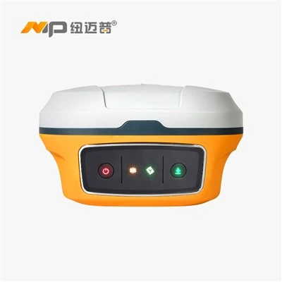
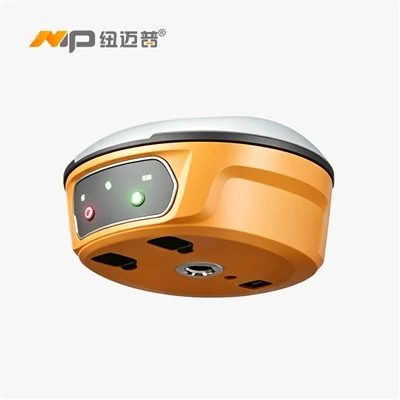
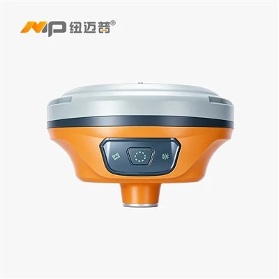
Product Introduction
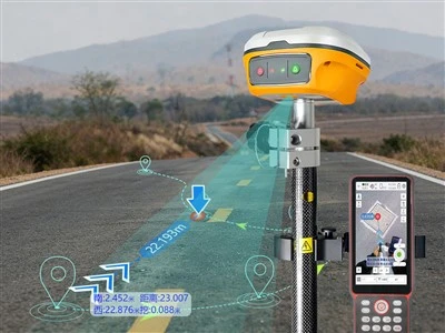
The N3 Laser RTK, equipped with Sinan's proprietary side-laser technology and a millimeter-accuracy laser module, offers a measurement range of up to 30 meters. Featuring carefully selected Class 3R green light that remains clearly visible even in bright conditions, it provides 360° panoramic measurement for an unparalleled working experience. With point-to-surface stakeout capabilities, it measures wherever the laser points, conquering complex environments and mastering the field of surveying.
Proprietary Side Laser Technology
Features carefully selected Class 3R green light that remains clearly visible even in bright conditions, with a millimeter-precision laser module embedded on the side, offering a measurement range of up to 30 meters.
360° panoramic measurement
Offers a unique working experience. With point-to-surface stakeout measurement, it's contactless and faster. Whether it's hazardous, complex, or indoor locations, simply point the laser and have precise measurements at your fingertips.
Inertial Navigation System (INS)
No initialization required-ready to use right out of the box. Tilt measurement and point-and-measure functionality for greater efficiency.
Product Parameter (specification)
| English Parameter | numerical values / Specification |
| GNSS Configuration | |
| GPS | L1C/A, L2P, L1C, L2C, L5 |
| BDS-2 | B1I, B2I, B3I |
| BDS-3 | B1C, B2a, B2b, B2b-PPP (infer) |
| GLONASS | G1C, G1P, G2C, G2P, G3 |
| Galileo | E1, E5b, E5a, E5AltBoc, E6c |
| QZSS | L1C/A, L2C, L5, L1C, L1s, L5s, L6 |
| NAVIC | L5 |
| SBAS | L1C/A, L5C |
| Number of channels | 1590 parallel channels |
| Accuracy & Reliability | |
| Static accuracy | Horizontal: ±(2.5 + 0.5×10⁻⁶·D) mm |
| Vertical: ±(5 + 0.5×10⁻⁶·D) mm | |
| RTK accuracy | Horizontal: ±(8 + 1×10⁻⁶·D) mm |
| Vertical: ±(15 + 1×10⁻⁶·D) mm | |
| e-RTK accuracy | Horizontal: ±(200 + 1×10⁻⁶·D) mm |
| Vertical: ±(400 + 1×10⁻⁶·D) mm | |
| RTD accuracy (horizontal) | ±1 m |
| Smoothed single-point accuracy | Horizontal: ±0.25 m |
| Vertical: ±0.50 m | |
| SBAS differential accuracy | < 1 m 3D (RMS) |
| RTK initialization time | < 5 s |
| Signal re-acquisition | < 1 s |
| Initialization confidence | > 99.99% |
| Tilt measurement | ≤ 2 cm (within 30° tilt) [2] |
| Laser tilt measurement | 3D error ≤ 2.5 cm |
| Environmental & Physical | |
| Operating temperature | –30 °C ~ +65 °C |
| Storage temperature | –40 °C ~ +85 °C |
| Operating humidity | 100% non-condensing |
| Ingress protection | IP68 |
| Vibration / shock resistance | 2 m free drop |
| Housing material | Magnesium-aluminum alloy |
| Weight | 1.2 kg (including battery) |
| Display | 1.1-inch OLED color display |
| User interface | Built-in web interface for query, data processing and device management |
| Data Processing | |
| Position output rate | 1 Hz, 2 Hz, 5 Hz, 10 Hz, 20 Hz, 50 Hz (optional) |
| Data logging format | CNB, RINEX, etc. |
| Differential formats supported | CMR, RTCM 2.x, RTCM 3.x |
| Output formats supported | NMEA-0183 / Compass (custom binary), PJK plane coordinates |
| Storage | 8 GB, supports high-speed USB download |
| Electrical Specifications | |
| Receiver power input | DC 6 – 28 V |
| Power consumption | 1.7 W (static mode) |
| Interface | Expandable up to 921600 bps |
| Li-ion battery | > 26 hours operating time in standard mode |
| Handheld (R50) | |
| Operating system | Android 12 |
| CPU | 2.0 GHz high-performance processor |
| Display | 5.5-inch high-brightness color screen, 720×1280, sunlight-readable |
| Battery capacity | 7000 mAh |
| Touchscreen | GFF, glove-operable, water-tolerant (partial water on surface) |
| Keypad | 9-key numeric keypad |
| Ingress protection | IP67 |
| Dimensions | 229 mm × 85 mm × 20 mm |
| Weight | 390 g |
Product Feature And Application
Proprietary Side Laser Technology
Millimeter-level laser modules embedded on the side
- Carefully selected Class 3R green light, clearly visible even in bright light
- Side laser modules with a measurement range of up to 30 meters
- Millimeter-level laser ranging, centimeter-level positioning accuracy

360° Panoramic Surveying
Where the laser points, the survey follows
- Point-to-surface stakeout surveying: a whole new work experience
- Where the laser points, conquer complex environments and master the surveying field
- Hazardous sites, complex sites, indoor sites-the laser has it all under control

Revolutionizing Traditional Surveying
Inertial Navigation Without Sensors, Enhanced Efficiency
- Effective Integration of Satellite Navigation, Inertial Navigation, and Laser Technology
- Provides high-precision, highly reliable positioning and attitude data

7 satellites, 30 frequencies
Strong signal, locks in seconds
- Up to 1,590 channels
- Supports all system frequencies
- Over 50 available satellites
- Supports satellite-based PPP augmentation services

Prodection Details


Prodect Qualification

Exihibition Show

Deliver, Shipping And Serving

Latest News
Shandong Surveying Information Technology Co., Ltd. is a professional manufacturer and one-stop supplier of surveying and mapping instruments, with nearly 20 years of industry experience. We specialize in the production of RTK receivers, automatic levels, total stations and theodolites, and also act as an authorized agent for multiple well-known industry brands, covering a full range of engineering surveying tools, measuring instruments and experimental equipment. We integrate production, global trade, technical support and after-sales service, committed to providing global customers with high-quality products and professional solutions. We look forward to cooperating with you!


Hot Tags: nmp gnss rtk laser distance measuring n3, China nmp gnss rtk laser distance measuring n3 manufacturers, factory, gnss rtk, NMP Gnss Rtk Dual Camera N7AR, NMP GNSS RTK Inertial Navigation N7, NMP Gnss RTK Laser Distance Measuring N3, NMP Gnss RTK Laser Dual Camera N9, NMP GNSS RTK N1