


Product Introduction
Seven Constellations, 30 Frequencies-Worry-Free Signal Reception
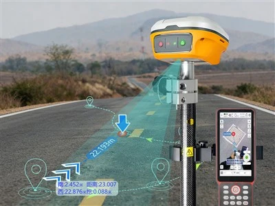
Fully supports BeiDou-3 satellite signals, with over 50 available satellites and up to 1,590 parallel channels for full-constellation tracking. Unfazed by obstructions, it delivers outstanding performance even in complex environments.
Satellite-based technology works even without an internet connection
A brand-new generation of satellite-based enhancement algorithms achieves centimeter-level accuracy. The RTK and satellite-based fusion algorithms enable faster satellite-based convergence. We provide Beidou B2B and Galileo HAS satellite-based services free of charge for life.
Third-generation inertial navigation system-highly efficient and convenient
No need for alignment within a 60° tilt angle; no need to check the bubble level; simply rest the pole on your shoulder and start measuring the moment you "tap,"
while maintaining centimeter-level accuracy, dramatically boosting surveying and staking efficiency
Product Parameter (specification)
| GNSS Configuration | |
| GPS | L1C/A, L2P, L1C, L2C, L5 |
| BDS-2 | B1I, B2I, B3I |
| BDS-3 | B1C, B2a, B2b, B2b-PPP |
| GLONASS | G1C, G1P, G2C, G2P, G3 |
| Galileo | E1, E5b, E5a, E5AltBoc, E6c |
| QZSS | L1C/A, L2C, L5, L1C, L1s, L5s, L6 |
| NAVIC | L5 |
| SBAS | L1C/A, L5C |
| Number of channels | 1590 parallel channels |
| Accuracy & Reliability | |
| Signal re-acquisition | ≤ 1 s |
| Time to first fix (TTFF) | Cold start ≤ 30 s, warm start ≤ 10 s |
| Pseudorange accuracy | Pr ≤ 10 cm, Cp ≤ 0.005c |
| PVT accuracy (1σ) | H ≤ 1.5 m, V ≤ 3 m |
| RTD accuracy (1σ) | H ≤ 0.3 m, V ≤ 0.6 m |
| RTK initialization time | < 5 s (baseline ≤ 10 km) |
| RTK accuracy | Horizontal: ±(8 + 1×10⁻⁶·D) mm |
| Vertical: ±(15 + 1×10⁻⁶·D) mm | |
| Static accuracy | Horizontal: ±(2.5 + 0.5×10⁻⁶·D) mm |
| Vertical: ±(5 + 0.5×10⁻⁶·D) mm | |
| Data update rate | 1 Hz, 2 Hz, 5 Hz, 10 Hz (measurement & positioning) |
| Data integrity rate | ≥ 99% |
| Environmental & Physical | |
| Operating temperature | –30 °C ~ +65 °C |
| Storage temperature | –40 °C ~ +85 °C |
| Operating humidity | 100% non-condensing |
| Ingress protection | IP68 |
| Vibration / shock resistance | 2 m drop onto concrete |
| Housing material | Magnesium-aluminum alloy |
| Operating time | ≥ 16 h |
| Dimensions | 123 mm × 123 mm × 70 mm |
| Weight | ≤ 900 g |
| Power & Electrical | |
| Supply voltage | 5 V / 9 V ±5% VDC |
| Power consumption | Receiver mode ≤ 1.8 W, transmission mode ≤ 3.6 W |
| Overvoltage protection | 30 V internal; protection activates when VBUS > 9.99 V |
| Tilt measurement | ≤ 2 cm (tilt angle ≤ 30°) (1σ) |
| Charging | Battery charging time < 5 h (supports QC fast charging) |
| Output Data Formats | |
| NMEA-0183 | GPGGA, GPGSV, GPGSGA, GPRMC, GPVTG, GPZDA |
| Interfaces | |
| USB port | Type-C |
| Pole mounting thread | Standard 5/8″ UNC internal thread |
| R50 Handheld | |
| Operating system | Android 12 |
| CPU | High-performance processor |
| Display | 5.5-inch high-brightness color screen, 720×1280, sunlight-readable |
| Touchscreen | GFF, glove-operable, water-tolerant (partial water on surface) |
| Keypad | 9-key numeric keypad |
| Battery capacity | 7000 mAh |
| Ingress protection | IP67 |
| Dimensions | 229 mm × 85 mm × 20 mm |
| Weight | 390 g |
Product Feature And Application
7 satellites, 30 frequencies-reliable signal reception
Strong signal, instant positioning
- Up to 1,590 channels
- Supports all system frequencies
- Over 50 available satellites
- Supports satellite-based PPP augmentation services

Third-generation inertial navigation system, measure instantly upon targeting
High precision, exceptional stability
- 60° tilt measurement for greater efficiency
- 5-second initialization-no need to check the bubble during measurement
- Easily obtain accurate data for measured points

Satellite-based technology: measurement even without internet connectivity
PPP-B2b, HAS
- A new generation of satellite-based augmentation algorithms, achieving centimeter-level accuracy
- RTK and satellite-based fusion algorithms enable faster satellite-based convergence
- Provides BeiDou B2b and Galileo HAS satellite-based services
- BeiDou B2b satellite-based service
- High-precision positioning

Prodection Details


Prodect Qualification

Exihibition Show

Deliver, Shipping And Serving

Latest News
Shandong Surveying Information Technology Co., Ltd. is a professional manufacturer and one-stop supplier of surveying and mapping instruments, with nearly 20 years of industry experience. We specialize in the production of RTK receivers, automatic levels, total stations and theodolites, and also act as an authorized agent for multiple well-known industry brands, covering a full range of engineering surveying tools, measuring instruments and experimental equipment. We integrate production, global trade, technical support and after-sales service, committed to providing global customers with high-quality products and professional solutions. We look forward to cooperating with you!


Hot Tags: nmp gnss rtk inertial navigation n7, China nmp gnss rtk inertial navigation n7 manufacturers, factory, gnss rtk, NMP Gnss Rtk Dual Camera N7AR, NMP GNSS RTK Inertial Navigation N7, NMP Gnss RTK Laser Distance Measuring N3, NMP Gnss RTK Laser Dual Camera N9, NMP GNSS RTK N1