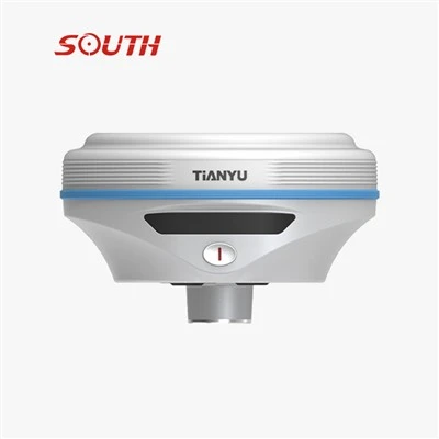
Product Introduction
- Multi-Constellation High-Performance GNSS Engine
1598-channel full-constellation reception, supporting major systems such as BeiDou-3, GPS, GLONASS, Galileo, and QZSS, and compatible with signals across all frequencies.
Initialization time < 10 seconds, reliability > 99.9%; it can quickly acquire a signal and operate stably even in complex environments such as dense forests and urban areas.
- High-Precision Positioning Performance
0~60° IMU Tilt Survey with 8mm+0.3mm/° Accuracy
Visual Stakeout Camera
Features a built-in 2-megapixel HD camera with a 75° ultra-wide-angle field of view and supports AR layout.
The mobile app displays real-time on-site footage and features AR guidance arrows, allowing even beginners to locate points quickly and boosting layout efficiency by over 50%.
Product Parameter (specification)
| Category | Item | Specification |
| Measurement Performance | Signal Tracking | 1598 channelsBDS-2: B1I, B2I, B3IBDS-3: B1I, B3I, B1C, B2a, B2bGPS: L1C/A, L2P, L2C, L5, L1C*GLONASS: G1, G2, G3*Galileo: E1, E5b, E5a, E5 AltBoc*, E6c*SBAS: L1C/A, L5*QZSS: L1, L2C, L5IRNSS: L5* |
| GNSS Features | Positioning output frequency: 1Hz ~ 20HzInitialization time: < 10 seconds Initialization reliability: > 99.9%Full constellation reception technology, supporting signals from all current and planned GNSS constel lations High-reliability carrier tracking technology improves carrier accuracy and provides high-quality raw observation data Intelligent dynamic sensitivity positioning technology adapts to various environmental changes and harsh, long-distance positioning environments | |
| Positioning Accuracy | Static Measurement Accuracy |
Horizontal: ±(2.5mm + 0.5×10⁻⁶D) mm Vertical: ±(5mm + 0.5×10⁻⁶D) mm(D = measured baseline length) |
| RTK Measurement Accuracy |
Horizontal: ±(8mm + 1×10⁻⁶D) mm Vertical: ±(15mm + 1×10⁻⁶D) mm(D = measured baseline length) |
|
| Inertial Navigation (IMU) | Tilt Measurement | Built-in IMU inertial measurement sensor, supports IMU tilt survey function, automatically corrects coordinates according to the tilt direction and angle of the centering rod |
| IMU Update Rate | 200Hz | |
| Tilt Angle | 0° ~ 60° | |
| Tilt Compensation Accuracy | With 1.8m pole: RMS = 8 mm + 0.3 mm/°tilt (tilt = tilt angle) | |
| Operating System / User Interaction | Operating System | Linux |
| Buttons | Power button | |
| Indicators | Five indicators: Satellite light, Differential signal light, Bluetooth light, Power light, Charging indicator light | |
| Web Interaction | Built-in Web UI management backend, supports Wi-Fi and USB access to the receiver's internal Web UI management page; real-time monitoring of receiver status and free configuration of the receiver | |
| Voice | iVoice intelligent voice technology, intelligent status broadcast, voice operation prompts Default supports: Chinese, English, Korean, Russian, Portuguese, Spanish, Turkish | |
| Hardware | Dimensions | Φ130mm × 80mm |
| Weight | 780g | |
| Material | Magnesium alloy | |
| Temperature | Operating temperature: -45℃ ~ +75℃Storage temperature: -55℃ ~ +85℃ | |
| Humidity | Withstands 100% non-condensing humidity | |
| Protection Rating | Waterproof: 1m immersion, IP68Dustproof: Fully dust-tight, IP68 | |
| Shock Resistance | Withstands falls from a 2m measuring rod | |
| Electrical | Power Supply | 6-28V wide-range DC design with over-voltage protection |
| Battery | Built-in 6800mAh lithium battery, 7.2V | |
| Power Solution | Continuous operation time > 18 hours in dynamic mode (provides 7×24h continuous operation solution) | |
| I/O Ports | 5-pin LEMO (external charging + RS232)Type-C port (charging and data transmission)1 radio antenna port | |
| Communication | Radio (Pro Version) | Built-in receiving radio Operating frequency: 410-470MHzCommunication protocols: Farlink, FarlinkPro |
| Bluetooth | BT4.2 (BR/EDR+BLE) standard | |
| NFC | NFC wireless communication technology, supports automatic Bluetooth pairing when the handset touches the receiver (requires handset with NFC module) | |
| Wi-Fi | Wi-Fi Standard | 802.11b/g/n standard |
| Wi-Fi Hotspot | Wi-Fi hotspot function, allowing any smart terminal to access the receiver for personalized configuration | |
| Wi-Fi Data Link | The receiver can connect to Wi-Fi to broadcast or receive differential data through industrial handsets and smart terminals | |
| Data Storage & Transmission | Data Storage | Built-in 4GB solid-state storage, supports rich sampling intervals, up to 20Hz raw observation data collection |
| Data Formats | Static data formats: South STH, RINEX 2.01, RINEX 3.02, etc.Differential data formats: RTCM 3.0, RTCM 3.2 (input/output)GPS output data formats: NMEA 0183, PJK plane coordinates, binary codeNetwork modes supported: VRS, FKP, MAC; supports NTRIP protocol | |
| Sensors | Temperature Sensor | Built-in temperature sensor with intelligent variable frequency temperature control technology, for real-time monitoring and adjustment of receiver temperature |
Product Feature And Application
Instant positioning upon startup
Powered by a BeiDou SOC chip and the all-new ROS system, it achieves positioning within seconds of startup

Ultra-lightweight, Stylish, and Minimalist
· Weighing just 780g, this device features a highly integrated, stacked design and a magnesium alloy body. Its compact size and lightweight construction make it ideal for fieldwork.
·With a three-section design, intuitive controls, and multi-color indicator lights, it exudes a sleek, minimalist aesthetic.

Inertial Navigation: Measure as Soon as You Point
Equipped with a built-in IMU (Inertial Measurement Unit), it automatically calibrates coordinates based on the orientation and angle of the alignment rod,eliminating the need for manual alignment-simply point and measure.
· Immune to magnetic field interference
· Calibration-free with low latency
· 200 Hz update rate
· 60° wide measurement angle

Extended Battery Life & Ultra-Fast Charging
Features a built-in 6800mAh high-performance lithium battery for up to 18 hours of battery life. With Type-C + PD ultra-fast charging, one hour of charging provides enough power for a full day of use. Supports charging via a power bank to meet the demands of more intensive tasks.

Prodection Details
")
")
Prodect Qualification

Exihibition Show

Deliver, Shipping And Serving

Latest News
Shandong Surveying Information Technology Co., Ltd. is a professional manufacturer and one-stop supplier of surveying and mapping instruments, with nearly 20 years of industry experience. We specialize in the production of RTK receivers, automatic levels, total stations and theodolites, and also act as an authorized agent for multiple well-known industry brands, covering a full range of engineering surveying tools, measuring instruments and experimental equipment. We integrate production, global trade, technical support and after-sales service, committed to providing global customers with high-quality products and professional solutions. We look forward to cooperating with you!


Hot Tags: south gnss rtk yuanhang, China south gnss rtk yuanhang manufacturers, factory, SOUTH 55x Magnification Level DSZ1, SOUTH Auto Level DSZ4A, SOUTH Electronic Total Station NTS 332R10, SOUTH Gnss Real scene Setting Out RTK C9, SOUTH Gnss Rtk Dual Camera S1, SOUTH Gnss Rtk Yuanhang